Monday, April 2, 2012

Mt. Nebo - Three Summits

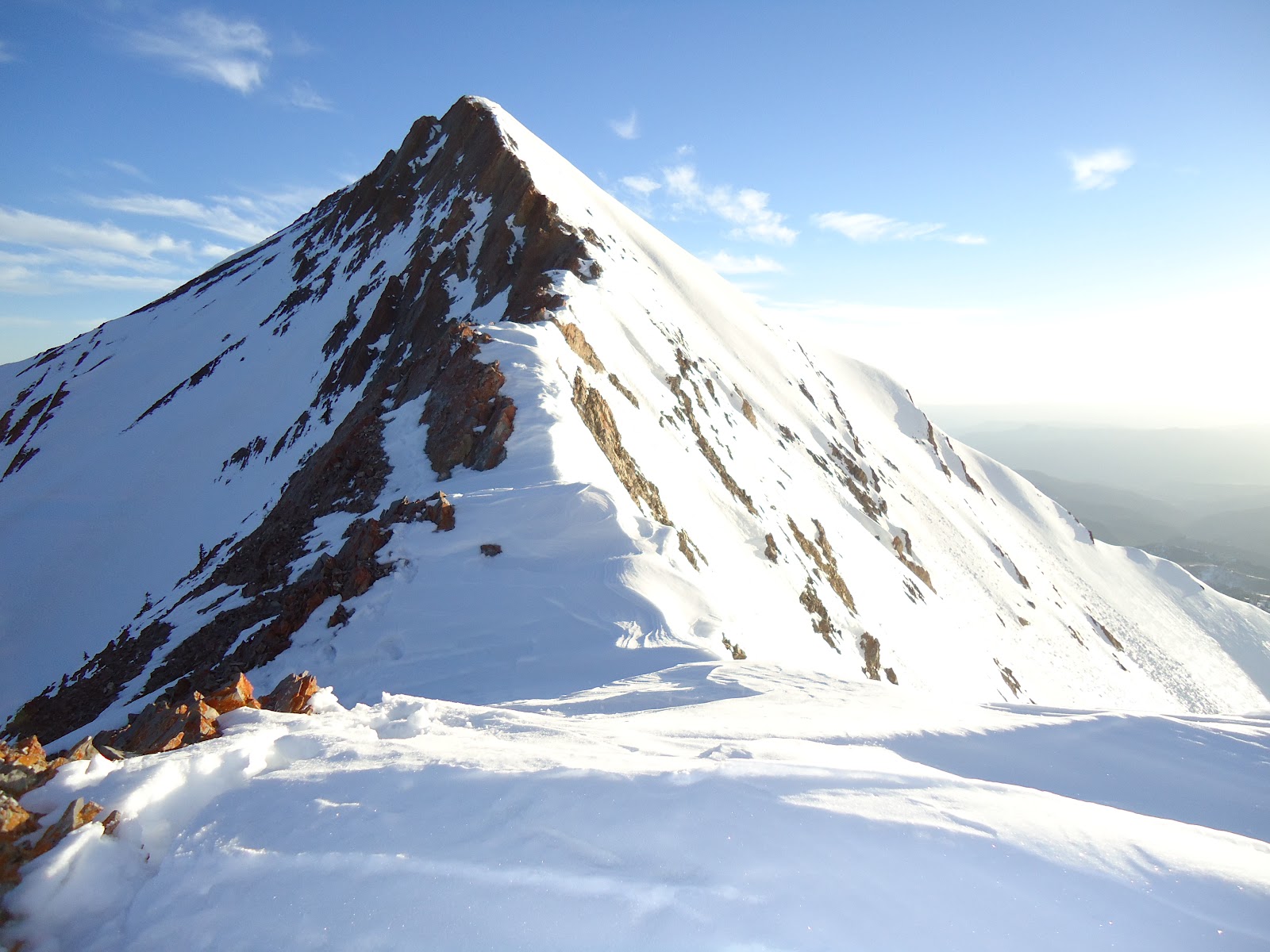
North summit of Mt. Nebo. 11,928 ft.

On a hot Friday afternoon the Utah Climbing club and I left the Cedar Ridge trail head East of the tiny town of Mona. Our goal for the day was base camp at 10,000. So, with winter overnight packs we tromped up the rocky, dusty trail toward the cooler pine laden forests above. After lots of dirt, scree and bush-whacking we finally made it to the pines and snow (8,400 ft.) and put on the snowshoes. I was quite happy, not only to be done with the scree and brush but to get the weight of the snowshoes off my back.  After about a thousand ft. we paused to watch 6 bull elk, most looked to be 4 point bucks, cross about 50 yards in front of us. It was pretty cool watching them bound through chest deep snow as they crossed over to a different mountain ridge.
David and his tent he kindly shared, surrounded by walls of snow

At around 9000 ft. my usual nemesis leg cramps cropped up making me stop for a few minutes here and there to let my legs relax and regroup.  Dropping my knees and legs deep into the snow seemed to help with a little natural icing down of the muscled. I was on the tail end of the first group of 5 to make base camp. By the time I got there my tent partner David had found a suitable spot with trees to the South that would help block the forecasted 50 mph winds. We didn’t get much of a break, but I did get to take off my 40 lb. pack, as we started digging out the snow to make a level spot of ground and build up a nice snow wall that worked well as a wind break.  Slowly the rest of the club straggled into camp. Lots of calls to borrow shovels and Steripens were heard as people dug out pits and melted snow for water. My Steripen was the champ of the night and my JetBoil stove was not. The JetBoil works great to boil water, but quickly slows down after a few liters when melting snow for water. The fuel just gets too cold and inefficient burning to deliver enough heat.

At around 10 pm we finally got our food cooked and enough water to get us through the summit march the next day. As is usually the case we found out that our flat base, wasn’t that flat. I had a big lump under my back making it impossible to find a comfortable position to sleep and David had his head on the downhill side of his feet, making his night less than idea. After an eternity I checked my watch to see that the time was 2:38 am, with a wake-up time of 3:00 I wasn’t thrilled. I managed to fall asleep for 15 minutes then it was time to get up and get to it. I dug into my usual Pop-Tart breakfast, cheap, easy and lots of calories, but found later that they didn’t really have enough substance to keep my stomach from wanting more pretty quickly.

Lone climber on the top of middle summit
At 4:00 am four or five of us got started up the ridge to the South summit, the 2nd tallest of the Nebo peaks at 11,877 ft.  My summit pack was nice and light but my lungs were still feeling the altitude. We crept up the 1800 or so feet to the south summit in the dark. I paused for a moment on the bump on top then turned to the north to start down the ridge toward the middle and north summits. When we got to the low point between the south and middle summit we found a very narrow rocky ridge with lots of exposure on both sides. Working across this ridge, using my rock skills was a little scary in the dark, but we got it done and headed up the steep middle summit climb.
Matt nearing the top of the north summit

Once on the middle summit (11,824 ft) I saw the sun was about to peak over the distant mountains so I paused to watch the orange rays come up and illuminate the lower mountains and hills below. Not much better in this world than being on top of a mountain watching the sun come up.  I couldn’t stay long as my hands and feet were getting cold so I continued north to the final summit. Between each of the summits the ridge drops a couple of hundred feet. The descent is a nice break, but starting the upward climb was a lot of work.  I was a few minutes behind 3 of my faster cohorts, having had to stop a couple of times to stick my hands in my armpits to get the feeling back in my fingers. I made the true summit of Nebo, the north summit at 11,928.  I snapped a couple of quick summit photos then headed down before the snow started to turn to slush.
Me on the north summit of Mt. Nebo


After getting back to camp, packing up and heading down on snowshoes the snow had turned to crap, really slushy and slippery making it difficult to keep my balance with my heavy pack.  After getting through the trees there were some great stretches to glissade. My butt got pretty soaked from the wet snow, but it was worth it cut out about 1000 ft.

The champ of the weekend was my Grivel Air-Tech Evo ice axe. It’s pretty light, about 1 lb. but it has a really strong shaft in case you need to belay off of it and it comes with a great leash that has a rubber cover for the shaft pick.  I’ve used this a few times in the mountains. I like the curved shaft near the head of the axe. It makes it nice and comfortable to carry and use. The head is forged and really tough. I used it for a bit of dry tooling here and there and there are no signs of use. I’m 6’3” and the 66 cm length is perfect for me. I was a bit worried that it might be too short, but I’ve found that any time I’ve needed it longer the slope is mellow enough that the axe isn’t all that needed. It’s on the steep stuff that I really like having it. Little nicks have come off the bright yellow paint from banging balled up snow and ice off my crampons, as well as knocking around on the rocks when I need to use my hands for a bit of climbing.  I like it so much that I keep it by my bed for both the good mountain memories as well as a home protection weapon. Can you imagine being an intruder and facing down someone wielding an ice axe. I wouldn’t want that buried in my skull, would you?

Big props to the climbing club, you’re all a lot of fun to hang out and climb mountains with. 

Thursday, March 22, 2012

Climbing Therapy

Sorry, yes another climbing post. With the lack of other things to do this time of year rock (plastic) climbing and winter mountaineering (and it’s subsets – snowshoeing/hiking) are about all there is to do right now.  A few nights ago, when my buddy was hanging on a route, waiting out a stiff forearm pump so he could work out a sequence, I had a brief conversation with this girl that was brand new to rock climbing. She was there with, what I presume, was her boyfriend, or given that the gym is near BYU it could have even been her husband. He had walked off to find a new route and she started asking me questions about rock climbing. How long I had been at it, strength and form, etc. I encouraged her to keep at it and both form and strength would come around.  She seemed encouraged, thanked me, and walked away with her slightly irritated boyfriend.

I realized at that point that I had gone to the gym in kind of a bad mood and wasn’t in a bad mood anymore. Not because of the conversation, but because of climbing. When you’re working a hard route, gritting out a sequence of small holds, it’s impossible to think about anything but the route and not falling, even on a top rope.  Climbing is very therapeutic. There are a lot of things out there that people find to be their own brand of therapy. Climbing happens to be a very good one for me.

There is one particular 5.10d route that I’m working at The Quarry. It starts out jogging to the left a bit on an overhanging wall, up onto a vertical wall on thin-ish holds, until the crux sequence with a big undercling movement to some big jugs above the roof.  I haven’t quite made it to the crux, just working the sequence to the hold right below it. When I made it to my high point on Saturday I had literally sprinted up the wall to get there, knowing that there was no place to rest or chalk up, and my fingers don’t have the strength to dawdle on those small holds. I made a diving grab for a decent hold and (because of poor foot hold choices) just missed it. I was left swinging out above everyone. My heart was racing and it felt good.

My own physical weight is more than enough to haul up a route, I can’t possibly carry any mental or emotional baggage up as well. If it’s a tough route I don’t think you have a choice. Everything but your harness, shoes and chalk bag stays on the deck. Fighting to move through thin holds to get to the next jug is a pointless endeavor in the scope of the existence we lead here on Earth. But, in terms of mental, and to some degree physical health, it’s incredibly helpful. By the time I walked out the door to my car that night I didn’t care about whatever it was that had put me in the bad mood, it just didn’t seem to matter.

I enjoy climbing. I like the mental and physical test that it provides. I can push myself through physical pain and the mental fear to accomplish new things. It’s fun to work on new skills. Focusing on using my feet better, maybe back step or drop-knee to make better use of a good stance. Ultimately, it’s the opportunity to forget the cares of the world for a few hours that I like the best. I don’t think it’s running away from life’s problems, it’s providing a fresh perspective. Put your day/week through a few hours of fun, fear and pain then deal with whatever is important enough to stick around afterward. 

Monday, March 19, 2012

Mt. Timpanogos - Redemption...almost

Last year my friend Rick and I made an attempt at climbing Mt. Timpanogos (Timp) via Everest Ridge on the West face. We planned on an overnighter, but never made it to our intended camp site on the Timp- Big Baldy saddle. We bumped up against heavy trees/brush, a large spring, and deep snow on the Battle Creek (North) side of Big Baldy.

Ever since then the massif that is Timp has been looking down at me, taunting me. Timp is a beautiful mountain and Everest Ridge is an awesome route running up the middle of the West face from Big Baldy to a point about .38 mile south of the summit. After a couple of weeks of heavy storms, heat, and massive avalanche danger everything finally settled down and Rick and I made our attempt.

We decided on a single day push from the bottom of Dry Canyon on the South side of Big Baldy. With snowshoes strapped to our packs we left the trailhead at around 5:20am. The temps were cold enough to keep the snow pretty solid until we got to near the saddle (~8000 ft.) where the snow was deeper and less consolidated. We moved up a prominent low angle ridge to the base of Everest Ridge where things got pretty steep. After a 100 yards we stashed our snowshoes next to a small band of rocks and switched to crampons and ice axes.

It was fantastic working our way up the ridge, watching the valley floor and Baldy drop below us. Most of the going was pretty steep, but stable crusty snow. A few stretches of post holing kept the heart rate up and made us extra grateful for the solid stuff. At one point, I think around 10,500 ft., there is a narrow, rocky ridge, that made the going a little interesting, and did a good job of breaking up the stretches of snow and post holing.


Rick and I finally made it to the cliff band, often referred to as the Step. We opted to traverse to the right (South) on a pretty steep slope. We got about halfway through the first section, after I slipped a couple of times and Rick admitting that his leg injury wasn't doing so well, we decided that we probably ought to cut it short and turn around.

Our high point was at around 11,300 ft. We dropped down a hundred or so to a place where we could glissade down the chute. There was a large crack across the face so we stayed far to the left so as to not tempt the avalanche gods. Just as we were about to start our slide down four college students, who were coming down from the summit stopped to watch. They had never heard of glissading down this section and were intrigued with not having to climb down the entire ridge.


After watching Rick and I they got enough courage to give it a try themselves. After that they were hooked and provided us with some ready made glissade tracks to follow down much of the mountain. After a lot of glissading and walking we made it to the cliff band where we had stowed the snowshoes. Only we were about 500 yards to the South. What proceeded was the worst period of post holing and swimming in waist deep snow that I've ever had. It was pretty late in the day and the snow was pretty soft and slushy. It took an hour or two (I really have no idea how long, but it felt like an eternity) until I was below the spot where I could finally see our snowshoes. Only problem, I had about a hundred yards to go strait up a 45 degree slope. At times I was literally moving on all fours, just trying to stay as near the top of the snow as I could.  I was about 30 ft. from the snowshoes and nearly gave up when I realized that 30 ft. was about a year in post holing years. Eventually I made it and after some trouble finally made it down to the bottom where Rick was wringing out his socks. He had followed me part of the way but had to give up when his leg injury started some serious nagging.
As is usually the case with me, once the climbing is done I get a strong mental urge to just get down to the car. The problem is that my knees don't like the quick pounding descent, so I'm forced to stop now and then to give them a break. 

Though Rick and I still didn't summit, I feel much more satisfied with this effort than last year when we were turned back so early. Timp still looks down on me, but its nice to look back near the summit to see just how close we got. I'll definitely have another go at it. Each time I learn some new lessons. Next time, if the weather is going to be warm, start much earlier in the morning and stow the snowshoes in a spot that I'll pass by on the way down. 

Thursday, March 8, 2012

Buckley Mountain - Awesome Mountain You've Never Heard Of

2:30 AM Saturday morning, the alarm goes off.  I dragged myself out of bed expecting to have a fairly mellow day climbing 9502 ft. Buckley Mountain. The Utah Climbing Club was scheduled to do Loafer Mountain and Santaquin Peak but extreme avalanche conditions forced a chance to smaller, less exotic, Buckley Mountain. Buckley Mountain sits right at the Provo – Springville border. Buckley, along with Y-Mountain and others are the shorter peaks that sit in front of the taller more well-known peaks like Provo, Cascade, Timpanogos, etc. I haven’t yet met anyone that has ever heard of Buckley mountain or paid any attention to it, despite the fact that it sits right there in front of everyone that lives in or drives around Provo.

My snowshoes and ice axe were already strapped to my pack. I just had to cram some oatmeal down my gullet and put some Carbo-Pro and Nuun in my water bottles. When I hopped in my truck the local radio station KRCL was playing late-80’s/early 90’s hip hop. All the stuff I listened to in Jr. high and early years of high school:  Humpty Dance, Buffalo Stance, Mama Said Knock You Out. It was a good morning.  This was my first outing with the Utah Climbing Club so I popped into the Mountain Works climbing shop to meet everyone else. Everyone looked as bedraggled as I felt. We drove in a procession to the Bonneville Shoreline Trail head in south Provo. We headed south on the trail for a few minutes then turned and headed strait up the mountain. It was a steep grassy slope with no trail in the dark for about 1000 ft. until we got to a ridge saddle and turned north to where we topped out on Toad Rock. Toad Rock, apparently looks like a toad when viewed from some angle, but I couldn’t see it. We were hoping to head north off of Toad rock to the ridge connecting us to the route for Buckley, but a 50 ft. drop off a cliff turned us back.
Utah Climbing Club in action

After we dropped down below Toad rock and did a lot of bushwhacking we made it to the ridge and started a meandering traverse upward. Just when I thought we’d start working up through some rocks we cut down across a wide gully and strapped on the snowshoes.  Soon we were headed up, strait up. Luckily the snow had a pretty hard crust so the snowshoe crampons dug in and we worked out way upward. At one point we had to do some small bits of low angle 5th class rock climbing. I let my poles hang from my wrists as I used my hands and the front points on the snowshoe crampons to climb up the short sections of rock. This was easily the most technical route I’ve ever done in snowshoes.

Summit of Buckley Mountain
Unfortunately the hard crust was not as consistent up higher and much of the going was through several feet of powder snow.  Stepping very gingerly sometimes helped and other times I plunged through the snow with a depressing slide back to my last step. After what seemed like an eternity I finally made it to the top of that section and turned to follow the ridge to the final summit ridge. Before continuing though I figured I’d better get some nourishment in me. I pulled out the peanut butter and Nutella sandwich, which was now nearly frozen. The sandwich turned out to be the tastiest thing I’ve ever taken with me on a hike or backpacking trip. I wished I had made two of them. Oh well. By now the wind was howling pretty hard and the temperature was dropping. I put my thin down jacket on under my softshell and worked up the ridge through deep powder, over rocks and logs and trees. Finally the summit ridge was there. The snow was wind-blown hard and crusty making the last 100 yards pretty easy.  I snapped a couple of quick summit pics then started heading back down before my fingers froze off. Temps on the summit were probably around 0F, colder than anything we’ve had all Winter.
Tricky section to descend

Usually when snowshoeing the descent is pretty easy and fun, this was not. There were all sorts of boulders and rocks hidden under the snow so that if you slipped on your snowshoes you could fall and gash a knee or hip and make the rest of the 4500 ft. trip down very hard. After some time a lot of the tracks had become a narrow powdery gully, perfect for some glissading now that we were past the rocks. The sliding sections were fairly short, but sure helped take off some of the knee strain and add in some fun. 

I connected up with about 4 other people from the club and we decided to head down a gully instead of heading back the way we came. This allowed us to keep on the snowshoes and slide, plunge step down the snow instead of working back up to the high ridge and back down the steep grassy slope to the bottom. Still it took about 3.5 hours to get down the gully and hike the BST back to the trail head.

Black Diamond Epic 45, packed up and ready for
Mount Timpanogos on this weekend
Through the whole ordeal was my trusty new-ish Black Diamond Epic 45 backpack. I bought the pack last Fall specifically for ice climbing and winter mountaineering.  The driving features for winter use are the ice tool pocket and crampon pouch. Instead of the usual ice axe loops that many packs have, the BD Epic has a nice pouch that you tuck the ice picks into from either side, keeping you from ripping up other gear with point parts. The ice tool handles are secured with a simply cord that is snugged up near the lid of the pack. The back of the pack has an extra tough layer of nylon that when coupled with a couple of straps and  a 3 inch strip of nylon make a great pouch that you can stick your crampons in. Making it both easy to retrieve or put them back as you’re moving across varied terrain. So, not only do I not have to dig through my pack to find them, but they aren’t ripping holes in my favorite light down jacket either.

I found out doing this trip that the cinch straps on the side are perfect for strapping snowshoes to the pack. The size is nice and versatile. I’m not an “Ultralight” backpacking kind of guy so an extra  2 oz of fabric doesn’t bother me. This allows the pack to be big enough to stow a 70M rope and ice climbing gear.  I could probably get away with a 30L or 35L for most day trips to the mountains, but cinch it down and you don’t notice the extra material anyway. Black Diamond packs have an awesome hip belt feature that pivots behind the lumbar support. This enables the pack to move more naturally with you as you move. No hip straps shifting around, or stiff body strapped to a pack unable to maneuver normally. I wish my other packs had this feature. All of the other features are well thought out. The shoulder and hip straps are padded nicely and keep the load supported comfortably. The lid has a top pocket where I like to keep food and headlamps. There is also a pocket on the underside of the lid.

After all is said and done. Buckley Mountain should be a tick on everyone’s list. It really was an alpine adventure. It may not have required crampons and an ice axe, but it had just about every other type of terrain you could expect in a mountain trek. Though I may not have paid any attention to Buckley before I know I’ll look up at it from the valley with fondness from now on. 


Thursday, March 1, 2012

Muir and Me

Anyone who’s done any rock climbing, mountaineering, or maybe just anything, knows that rather often you fail to accomplish the goal you set out to do. This is certainly the case with rock climbing and mountaineering for me. In cycling, I know enough about myself to set my goals nice and low so that I don’t get disappointed quite as often. The problem with climbing rock and ice is that people have set grades to them. I started climbing 5.6 then moved up to 5.7 on up to 5.10 and so on. The problem is that these grades are so dependent on the experience of the climber that set the grade as well as that person’s personal strengths and even their size. Bigger is not always better either. Sometimes a route, this happens more often indoors, is set by someone much smaller than me (6’3”). The hand and foot holds end up too close to each other, but to far apart to stretch to the next set. So, I get stuck making some tricky moves with my body all cramped up. 

Most mountains don’t have difficulty grades, and if they do the mountain is usually technical enough in nature that you better be fit and knowledgeable before you attempt them. Weather, snow conditions, temperatures, fitness and recovery for the day, all play into success of any venture into the mountains.

If I’m heading out for a new objective usually I’ll have done some research on it, thank you internet. This means if I’m picking a rock route I know what my grade limit is and I’ll choose some fun routes that I think I have a reasonable chance on. Sometimes I’m right and sometimes I’m wrong.

I’m usually upbeat enough and not tied so emotionally to my goals that if I fail I’m not too broken up by it. If that’s the case then I usually just look around at the surrounding mountains, rocks and trees and think how lucky I am that I’m able to spend those few hours in the mountains. My oft repeated statement in these times is “Any time spent in the mountains is a good time.” And it’s the truth. I’ve come to realize that most people seem to feel some kinship with the mountains, so I don’t think it’s just me. While walking up Rock Canyon on our way to Provo Peak my friend Dave exclaimed, “I love the pines,” which was a tad surprising to me only because I’ve said the same thing a number of times. Something about pine trees is so calming and comforting. Dave thinks it’s the majesty of them, so tall and strait. The fragrant green boughs overhead along with the flaky and gnarled bark on the trunks make a pine forest a true joy to walk through.

I’ve been reading a giant 800+ page compilation of the works of John Muir for the last few months. I usually find an hour or two per week to read so it’s slow going. I love the mountains. John Muir loves the mountains like my 6 year old loves chocolate, like Darth Vader loves choking people with the Force, like the programmers that I work with love Mountain Dew; you get the idea. As much as I love the mountains John Muir has opened my eyes further to all the beauty that abounds. This man loves the pines. He also, like me, has an affinity for rock formations and the geologic forces that it took to get them there and in that shape and condition. This especially applies to the great massive grinding force of glaciers. Muir marvels equally at the beauty of the soaring granite peaks as he does the ability for squirrels to clamber around in pine trees eating the nuts and somehow do so without getting any sap or mess on their fur.

The fact that I have three canyons and the Wasatch range within 15 minutes of my driveway is of incredible importance to me. I used to have an office cubicle next to a window that faced Mount Timpanogos and Lone Peak. Often, when I needed a break from staring at a computer screen, I’d swivel my chair a few degrees and trace ridges to the tops of the mountains, looking for new interesting routes to reach those highest peaks. I dream of hiking the canyons and listening to the wind blow through the trees until it sounds like a roaring river. Or, scaling a cliff face straining to hang on to that tiny hold long enough to clip the rope into the next bolt. I may fail to top out, I may fail to summit a peak, but it’s all time spent in the mountains, and that can only be good.

Monday, February 27, 2012

Attempt at Provo Peak

Plans for departure times went back and forth, but eventually we ended up getting under way at 9:09 am from the Rock Canyon trail head in Provo, UT.  Our destination for the day was obscured by other peaks and mountains, but we knew that Provo Peak (11,068 ft.)was back there. The lack of snow this winter meant that we started off with our snowshoes stowed on our packs as we started up the familiar trail in Rock Canyon. I admired the many rock routes that I had climbed this past Summer as we strode by. Part way up the trail started to get a little icy, but the trail was low angle and knowing that we wouldn’t encounter snow for quite a while we just stepped gingerly in the especially slippery parts.

After about an hour we connected to the Squaw Peak Trail. Dave and I had never been on this trail so it was new territory for us both. We stopped for a quick snack/water break. While stopped we had a chat with David Sheets, owner of Emergency Essentials. It turns out Dave worked for David almost 20 years ago. They did a little catching up and David told us how he had nearly ran into a bear this past summer,  just 30 yards from where we were standing. Bears in the vicinity, check.

The snow was now getting deep, but the trail was so well traveled and packed down, that we kept the snowshoes on the packs. Another 20 minutes and we were in the Rock Canyon campground, neither of us had any idea that this campground existed. It looks like a fun place to take the kids this summer.  Finally the snow was deep enough to need snowshoes so we stopped at one of the picnic tables to put them on. I checked the GPS to find the trail. There were about 3 trails that left from the campground that all sort of ended up converging at a later point so we took what looked to be the shortest route and started off. After a while we came to a gate and no trespassing sign. Hmmm. Check the GPS and we had missed a turn-off somewhere.  We weren’t too bothered by the back tracking, we were making good time and had plenty of energy. We decided to cut through some woods to where the GPS indicated that we would connect back with the trail. After a while we checked the GPS and we were way off of the trail now.  Oh man.  Time to double back again. This time we had a struggle up the side of a very steep stream bank. Now that we were getting close to the trail we decided to cut through some more woods to keep forward momentum.  Bad idea. When we checked the GPS after a bit we were just as far off as before. This time we headed strait for the indicated trail on the GPS so that we could finally get on course. This meant we had a couple of very high and steep bluffs to climb. It was starting to get hard.

I crested the final ridge and stopped on an obvious trail. I wasn’t about to be fooled by going down the wrong trial so I checked the GPS. It indicated that we were still a ways off from the trail, still in the direction that we were headed so we started up another steep ridge.  The ridge wasn’t the trail, but we decided to just follow the ridge in the direction of Provo Peak, not wanting to get rid of the elevation we had gained by climbing it. The ridge provided a nice view into Utah Valley and all the surrounding canyons. The only problem was the increasingly thick growths of scrub oak. A little bush-whacking never hurt anyone, so we continued on. We spotted a clearing on the ridge where the incline grew steeper and made that our goal, then we would stop for a break. Once we got to the start of that section fighting the incline and depth of the snow began to make things really tough. It was slow going, often fighting for 5 minutes just to make a couple of forward steps. Finally we made our goal, some large rocks on the edge of a small 20 ft. cliff. We stopped for lunch and a rest. I decided to check the GPS to find out exactly where we were. I discovered that the  trail that had been on was indeed the correct trail. Lesson learned, don’t always trust the GPS as gospel.

Provo Peak was now in our sights but it was another mile or two further plus 1500 ft of steep climbing. We decided to climb to the top of the ridge that we were on and call it good. After a big of a rest we got back to it and were quickly reminded that the mountain was not for or against us, it was just there. Steep and covered in deep snow.  At some point we can across tracks of some sort. They had plunged down into the snow and were a day or two old. Without any real defining characteristics we couldn’t figure out what had left the tracks. Then we came to a place where the animal had walked a little more softly and stayed on the surface. Big mountain lion prints were clearly visible. Knowing that the tracks were not recent we weren’t really concerned, but I kept my eyes open hoping to catch a glimpse of  a big cat.

After an eternity we finally came to the top of a false summit. My legs had started cramping and we were just plain exhausted so we called our adventure good decided we had gone far enough. After a quick sock change we started the downward part of the trip. Dave, whose knees were now hurting quite a bit did not have fun. I on the other hand had a blast. I moved onto the untracked snow and basically skied down the slopes. It was a bit awkward, and I ended up on my backside more than a couple of times, but it was fast, easy and a lot of fun.

We eventually made it back to the trail that the GPS had tricked us off of and followed it back to the campground so we could remember for the next attempt. Provo Peak is a fairly unknown peak. It can be seen from the valley, but it’s back behind other peaks and though it’s nearly as tall as Timpanogos, the most popular peak in the area, it does not appear as prominent so it goes fairly un-noticed. As far as peaks go, it’s a pretty good looking peak. I wish I had taken a picture of it.

I was able to test a cool new gadget that showed up the day before this outing. The LifeProof iPhone case. The case is shock resistant and waterproof. I have friends that have Otter Box cases for their phones and they work well, but they had quite a bit of bulk to the phone and I’ll just go without before I have to carry around something that bulky in my pocket or pack.  The Lifeproof case, using some shockingly thin plastic, is able to protect the iPhone from normal drops and in the case of the rep at the Outdoor Retailer show, a toss across the booth. The rep also demonstrated the waterproofness of the case by dropping his phone into a tank of water. I haven’t tested my personal phone but the rubber seals around the joints all seem to be well designed and implemented. The touch screen seems to have just the tiniest amount of difference in sensitivity. Not enough that it bothers me and not enough that it causes any issues with typing out a text or email.  The iPhone auto-correct still causes me more problems than any real or perceived loss of touch sensitivity will.


Between the awesomeness of my Goal Zero Guide 10 battery pack and the LifeProof case, I was able to have access to my ill-performing GPS for the entire 8 hour outing in the backcountry. If you have any need for a waterproof case or worry about dropping and cracking the screen on your $500 phone then the $75 for the LifeProof case is well worth the dough.

Dave and I will go back to Provo Peak in a month or so when schedules have cleared up and we’re ready to give it another go. Next time we’ll follow the trail and save our climbing legs for the actual peak. Maybe we’ll even see that mountain lion…

Monday, January 16, 2012

Ouray Ice Climbing

The winter snowpack is the worst it’s been in a decade and the temperatures have been well above typical January levels but most of the ice routes in Provo Canyon are looking good. I think this is mainly due to snow melt from above that drips down to the shady north facing cliffs and freezes up. I drive up the canyon about once week to check out the popular routes always expecting to see them all melted out but they’re sticking around.  Good for me and good for the hordes  of climbers that I saw on Stairway to Heaven last weekend. 


Anyone that has any interest at all in ice climbing knows that Ouray CO is one of the destinations you need to visit.  I planned a trip with my pal Rick Miske to spend a couple of days climbing ice in Ouray between Christmas and New Years.  Rick has spent a good amount of time climbing ice in Ouray so he was our guide. For Rick's take on the trip and lots of great photos check out his blog http://climbingfamily.com/blog/2011/12/31/ice-climbing-in-ouray-december-2011/
Schoolroom - Rick kindly offering some mints


I don’t think any of the ice in the Uncompahgre Gorge, the river gorge that makes up the Ouray Ice Park, is naturally occurring. Some enterprising individuals started farming the ice there a few years ago and have expanded the number of routes each year since. All along the top of the gorge are lines of insulated sprinkler pipe hooked to shower heads. Each night the Ouray Ice Park volunteers head out and turn on the water to make more ice. Very cool. 


We got up early the first morning and headed to the schoolroom area. We were one of the first few people to set up a top rope on the anchors at the top of the 80’+ routes.  Since Rick and I normally climb at night it was kind of cool and different to see so many other people drop down and set up ropes to climb. Over the course of the two days we we traded ropes with a few people, making it easy to swap routes and try out some new things without having to pull the rope and set up another anchor. Everyone was really friendly(with the exception of a couple of Brits that decided to take over one of the routes we were going to do).  The 1st pitch of ice that we normally climbing in Provo is around 50’ so the added 30’ or so made the climbing much more sustained and the couple of ledges on the way up offered a very welcome rest.  The route we spent our time on in the school room had about 50’ of strait vertical climbing with some variety to try out the different forms of ice that were found. On one run I decided to move out onto a curtain then continue upward.  My feet had popped a little lower on the route, but my ice tools stuck so I managed to hang on. By the time I’d made it about 10-15’ above the bottom of the curtain my arms were pretty pumped and I had to call for Rick to take so I could get a rest. I intended on hanging on to the ice a little and just having Rick take up some of the pressure, but apparently I was more tired than I thought because when I relaxed my stance a bit I popped off the ice. Then got a surprise when my weight pulled Rick forward about 10 ft. and I continued my downward plunge. Rick managed to get his feet stuck to the ice on the (luckily) frozen stream and stopped my fall. We had a bit of a chuckle about that one. 
Random Strangers in the Scottish Gullies. 
After a few runs in the Schoolroom we headed over to the Scottish Gullies. The Scottish Gullies area offers a lot of variety. The routes are a tad shorter, around 65’ for so, but the cliff face in the gorge meanders in and out with jutting rocks which create some really cool and fun ice formations.  After the route we wanted to climb was snaked by the guys I mentioned earlier we moved over to a fairly low angle climb. Because the obvious route line was lacking in technical difficulty we played around on the walls and ice formations that were on either side.  Finished up the day with around 500 vertical feet of climbing and saved something in the tank for the next day. Rick and I recharged with a giant plate of pasta and chicken. I think we both over ate, knowing that we were probably in a calorie deficit for the day.   After a soak in the spring fed hot tub and we were feeling pretty good. 


The next day we got up early again, knowing that the weekend would bring a lot more people out to climb. We hopped on the route in the gullies that we had wanted to climb the day before. I was surprised to see how much more ice had formed from the sprinkler shower overnight. Everything that had been knocked off the day before had been replaced and then some.  The route, I think it might be called Aye Laddie had 3 main lines and a variety of other options to choose from. Everything from a slopey easy start to a little mixed/thin ice. Steep ice to smooth hard bulges or lower angle blobby ice to hook your tools into.  Except for one climb on a neighboring rope we spend the whole day exploring the variety and options this route had to offer. I literally climbed until my arms could handle no more.  


It was an awesome 2 days in Ouray and I hope to return in in late Feb. to get some more climbing in. It’s a great little town with lots of restaurants and just about the best climbing gear shop I’ve seen. The only problem is that everything is marked up to tourist prices.  I’ll save my money for MountainWorks.